Caprock Canyons State Park and Trailway

20181013_131336
We apologize for any neck pain that viewing this photo may cause!
  • Website link: Caprock Canyons
  • Hiking (25 miles of trails), biking, swimming, canoeing/kayaking, fishing, horseback riding. There is also a great scenic drive.
  • For RV and tent campers, Honey Flat Campground offers water, electricity, restrooms, showers, and a playground. Book early!
  • Tent and basic camping areas offer water only, and primitive campsites are also available in the park.
  • Equestrian campground available.
  • Backcountry camping is allowed anywhere along the Trailway. Check the website for Trailway information.
  • When to go: anytime. We like spring and fall.

20181014_084302

Caprock Canyons State Park, located near the small town of Quitaque (Kitty-Quay), Texas, is the home of the official Texas State Bison Herd. In addition to the bison (they have the run of the park, by the way) this park has stunning scenery and is a place to literally get away from it all. Set off on one of the great trails and immerse yourself in the rugged beauty of this West Texas gem.

20181013_154405*Caprock Canyons State Park is:

102 miles from Amarillo, Texas96 miles from Lubbock, Texas170 miles from Wichita Falls, Texas

Our trip is going to start from Lubbock, Texas, as it is the closest city with a major airport.


20181014_084530

Getting There

From Lubbock, take I-27 north toward Plainview, and then continue north to Tulia. At Tulia, take Highway 86 east toward Silverton, and then continue east to Quitaque. Drive time between Lubbock and Caprock Canyons: 1.75 hours.

Note: a visit to Caprock Canyons is an easy day trip from Lubbock or Amarillo, however, we recommend staying for a day or two (or longer) to enjoy everything this park has to offer.

There are a few accommodations in the area, including a bed and breakfast in Quitaque, a hotel in Turkey (11 miles east), and a couple of RV campgrounds. Here are the website links: Quitaque and Turkey.

Travel tip: there’s a vintage cottage gas station in Turkey that is worth driving the 11 miles to see.

20181013_133831.jpg
Restored Phillips 66 gas station in Turkey

Destination: Caprock Canyons State Park

20181014_084549
Misty Watercolor Memories! Caused by bright sun in the east and a cold front moving in from the west. The unusual lighting turned the red bluffs pink.

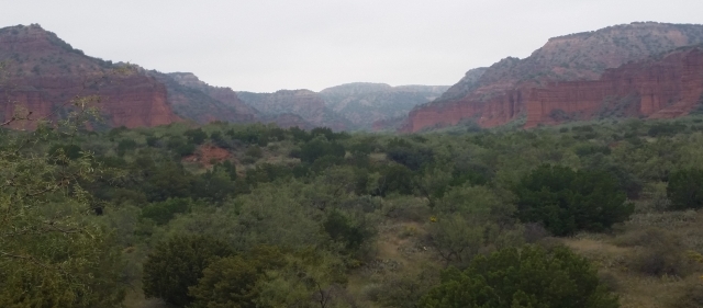
We hiked the Canyon Rim Trail on an overcast day. The scenery was gorgeous, but the pictures, unfortunately, do not do it justice. The wildflowers really put on a show, though.

20181013_164521
Looking  down in to the canyon from Canyon Rim Trail
20181013_163647
Wildflowers along Canyon Rim Trail

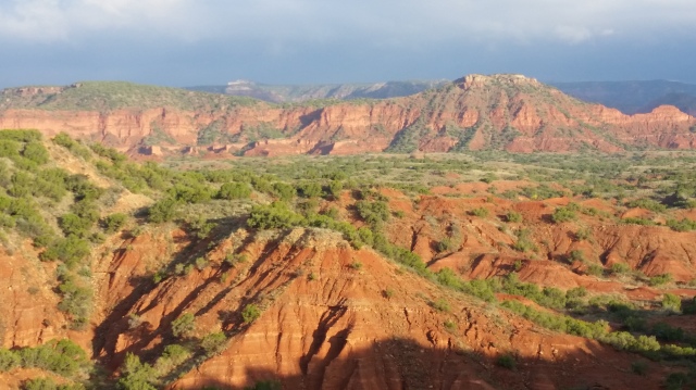
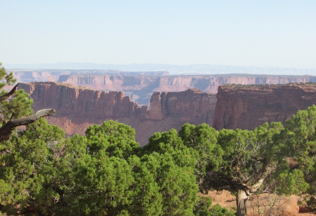
The scenic drive along the park road enables you to get up close and personal with some the features of the park. Below are a few shots of the beautiful scenery along the road.

20181013_115704
Creek bed with interesting geologic features in the cliff face
20181013_122320 (1)
Canyon perspective
20181013_122736
How did nature do that? And those plants!
20181013_114949
Panorama from a viewpoint along the road

Be sure to stop at the pull outs and learn about the park. While you’re at it, stop by the visitor center for books and information about Charles Goodnight and his wife, Mary Ann. They are responsible for preserving the predecessors of the bison herd that calls Caprock Canyons home. It’s a very interesting story, especially since American bison were once on the verge of extinction. We find the bison enchanting, and fun to watch, but always from a distance. These are wild animals that can be dangerous, and it is illegal to approach or feed them.

20181013_104329

The video below was taken early in the morning while the herd was walking from wherever they spent the night to a grassy grazing area.

That’s our overview of Caprock Canyons State Park and Trailway. Thank you for joining us. We hope that our post has prompted you to visit this great park. As we always say, “Just get in the car.” Please leave us a note and tell us about your trip to Caprock Canyons, or any of your trips for that matter. Maybe you will inspire us to take your trip!

20181013_115714

Travel safe, travel smart, and we will see you down the road.

Mike and Kellye

IMG_2120

As always, we strive to be as accurate with our information as possible. If we made a mistake, it was unintentional. (Hey, we’re only human!) We aren’t paid for our recommendations, and we only recommend our own tried and true vendors and venues. Our suggestions are for places that we’ve heard good things about but haven’t visited personally, and our opinions are our own.

©2018


Death Valley National Park

IMG_2653

  • Website: Death Valley National Park
  • Hotels/resorts and campgrounds in the park
  • Restaurants and concessions in the park
  • Scenic drives
  • Historic sites
  • Hiking
  • Backpacking
  • Backcountry camping
  • When to go? Winter, early spring, late fall are the best times to visit. Visitors should be extremely cautious in the summer months when temperatures rise dramatically.
IMG_2580
Devil’s Golf Course – these “rocks” are actually salt crystals. The Panamint Mountains made a nice backdrop for this shot.

Getting There

Our trip is going to start in Las Vegas, Nevada, which has a major airport and is only 123 miles from Death Valley. Ice down a cooler full of water, grab your favorite road snacks, and let’s go to Death Valley!

From Las Vegas, take I-15 south to Highway 160 west to Pahrump, Nevada.

Travel tip: make a restroom stop and top off your gas tank in Pahrump.

From Pahrump, continue northwest on Highway 160 to Bell Vista Avenue. Take Bell Vista (which changes to Bell Vista Road) west across the California state line to Death Valley Junction and Highway 190. Continue into the park on Highway 190. Drive time between Las Vegas and Death Valley: 2 hours.

Travel tip: Look for wild burros and horses along Highway 190.

Destination: Death Valley National Park

IMG_2601Arguably, Death Valley holds the record for the hottest temperature ever recorded on earth – 134º F in July of 1913. Badwater Basin is the lowest point in North America, sitting at 282 feet below sea level. With an average of 1.5 inches of rain per year, Death Valley also holds the honor of being the driest place in North America. We are used to hot, dry weather where we live, but the 111º F (before noon) temperature when we visited Death Valley felt like a different type of oppressive heat that seemed heavier to us for some reason. With that said, we caution you to be conscious of the weather and prepare for harsh conditions when visiting this park, especially in the late spring, summer, and early fall. Also, make sure your car is in tip-top condition before starting a road trip through Death Valley.

IMG_2602
This is a spring in the salt flats at Badwater Basin, but the water is too salty to drink.

Death Valley is hot, dry, and its spring water is too salty for humans or animals to drink. So why would anyone want to go there? Well, see below…

IMG_2610
Breathtaking Beauty
IMG_2611
Vibrant Colors at Artist’s Palette
IMG_2626
Magnificent Mountain Vistas

When thinking of a desert, one usually thinks of sand dunes and scrubby cactus. At least that is what we envision when we imagine desert scenery. Death Valley is different from other deserts because of its diversity. The park features 11,000 foot mountains, wildflower super blooms after rare rains, as well as sand dunes. Badlands, salt flats, and dry lake beds where rocks race across the parched ground on their own, can also be seen here. With so much to offer, it’s easy to see the many facets of this unique landscape. And speaking of lake beds, all of Death Valley was once a lake. A trip here is definitely worth the time, and it’s not just about the scenery. This park also features oases, historic ghost towns, abandoned mines, and even a castle!

IMG_2629
Badlands of Zabriskie Point
IMG_2606
Salt Flats of Badwater Basin
IMG_2632
Multi-faceted Beauty

Did you know that borax was once mined in Death Valley? The mine was called Harmony Borax Works, and they hauled the borax 165 miles to Mojave, California, using huge wagons pulled by teams of twenty mules. One of the wagons can still be seen at the Furnace Creek Visitor Center. The trip from Death Valley to Mojave took ten days and had to have been grueling. Today at Death Valley, there is a park road through scenic Twenty Mule Team Canyon. While the wagons probably didn’t travel this exact area, it is a wonder how they managed to get their animals and wagons through the rugged terrain of what is now Death Valley National Park.

IMG_2639
In Twenty Mule Team Canyon
IMG_2636
View of the terrain and park road through Twenty Mule Team Canyon

Thank you for joining us on our trip to Death Valley National Park! We hope that we have given you some insight and inspiration for planning your own trip to see this wondrous place. That is our goal in sharing our information, after all. We will leave you with one last look at beautiful, otherworldly Zabriskie Point.

IMG_2631

Until the next trip…

Travel safe, travel smart, and we will see you down the road.

Mike and Kellye

IMG_2120

As always, we strive to be as accurate with our information as possible. If we made a mistake, it was unintentional. (Hey, we’re only human!) We aren’t paid for our recommendations, and we only recommend our own tried and true vendors and venues. Our suggestions are for places that we’ve heard good things about but haven’t visited personally, and our opinions are our own.

©2018


Scotts Bluff National Monument

IMG_1126

Where is Scotts Bluff National Monument Located?

The monument is located near Gering, Nebraska, USA

  • Website: Scotts Bluff National Monument
  • Visitor center and Summit Road hours vary seasonally. Check website for details.
  • Summit Road scenic drive.
  • Hiking, biking trails.
  • Exceptional museum and visitor center.
  • Accommodations and restaurants in the city of Scottsbluff.

IMG_1152

First things first… Please note that we have not misspelled the name of the monument or the name of the city near where it is located. Scotts Bluff (two words) is correct for the name of the national monument. Scottsbluff (one word) is correct for the name of the city. Now on to Scotts Bluff…

Scotts Bluff National Monument is: 96 miles from Cheyenne, Wyoming195 miles from Denver, Colorado — 200 miles from Rapid City, South Dakota

Cheyenne has a regional airport that is served by several national carriers, so our trip is going to start in the capital city of Wyoming.

Wyoming Capitol Building

Travel tip: we recommend a stop at the Cheyenne Depot Museum. Learn how this historic depot was instrumental in the development of Cheyenne as well as its importance during the construction of the Transcontinental Railroad. Here’s a link: Cheyenne Depot.

Getting There

From Cheyenne take I-80 east via Pine Bluffs, Wyoming. At Kimball, Nebraska, take Highway 71 north to Scottsbluff. Drive time between Cheyenne, Wyoming and Scottsbluff, Nebraska: 1.75 hours.

Welcome to Nebraska! We were met by these snowy bluffs just after we crossed the state line.

Destination: Scotts Bluff National Monument

Visitor Center

The first stop upon arriving at the monument should be the Oregon Trail Museum and Visitor Center. Learn about the significance of the bluff as a landmark for pioneers who were traveling west on the Oregon, Mormon Pioneer, and California Trails as well as the Pony Express Trail. This outstanding museum also holds the world’s largest collection of artworks by the renowned artist and photographer, William Henry Jackson. Plan to spend some time in the museum before taking Summit Road to the top of the bluff.

Saddle Rock formation at the southeast end of the bluff
Summit Road

Drive your own vehicle to the top of the bluff or take the park’s shuttle. There is a trail at the top with excellent views of the features of the monument, the city of Scottsbluff and surrounding communities, as well as the North Platte River. We spent over an hour walking the trail and taking advantage of the great photo ops.

View from the top of the bluff

Travel tip: Some vehicles will not be able to navigate the sharp turns and tunnels on Summit Road. For those who have large vehicles or RVs, check with the park before attempting this drive.

IMG_1154
Saddle Rock from above
IMG_1164
From the summit trail, interesting geology
Significance of the Monument

Four historic trails passed through Scotts Bluff National Monument at Mitchell Pass, which lies between Eagle Rock and Sentinel Rock. Wagon wheel ruts can still be seen in Mitchell Pass today. Here is an excerpt from the National Park Service’s website:

“The bluffs of Scotts Bluff National Monument rise directly from the North Platte River, blocking wagon travel along the river’s south bank. At first, emigrants had to take a detour south and use Robidoux Pass, a natural gateway, to get through the bluffs. This mostly stopped in 1850 when a new route was opened at Mitchell Pass. Located close to the North Platte River, this route saved emigrants nearly 15 miles of travel. The route, though, was narrow, due to the land’s geography. As such, more than 300,000 emigrants, and their wagons and livestock, had to travel on the same strip of land.”

For information about the historic trails, click on their links below:

IMG_1128
This reminds us of the Old West. Can’t you just imagine a wagon train in this picture?
Five Landmark Rocks
IMG_1134
Eagle Rock
IMG_1129
Sentinel Rock
IMG_1144
Dome Rock
IMG_1130
Crown Rock
IMG_1127
Saddle Rock

Now we going to take a short jaunt to another important landmark on the Oregon Trail.

⇒Side trip: Chimney Rock National Historic Site. From Scottsbluff, take Highway 92 east approximately 21 miles, and follow the signs to the visitor center.

Chimney Rock

Chimney Rock is the iconic symbol of Nebraska and was an important landmark to the pioneers traveling the Oregon trail. Learn all about it at the Abbott Visitor Center.

IMG_1171
Chimney Rock, east view

Chimney Rock actually sits on private property. Visitors can view the rock from the visitor center or from the road.

Chimney Rock, very different north view

Thank you for joining us on our trip to Scotts Bluff National Monument. Please let us know if you have questions about this trip or any of our trips. Leave us a message/comment below and tell us about your own trips. We love hearing from you.

Need more national park road trip inspiration? Check these out:

Devils Tower Road Trip: Things to Do
Antietam National Battlefield
Fort Union National Monument


Travel safe, travel smart, and we will see you down the road!

Mike and Kellye

IMG_2120

As always, we strive to be as accurate with our information as possible. If we made a mistake, it was unintentional. (Hey, we’re only human!) We aren’t paid for our recommendations, and we only recommend our own tried and true vendors and venues. Our suggestions are for places that we’ve heard good things about but haven’t visited personally, and our opinions are our own.

©2018


Canyonlands National Park

IMG_2380

  • Website: Canyonlands National Park.
  • Camping available in the park. Backcountry camping available with permit.
  • Hotels and restaurants available in Moab, Utah.
  • Hiking, biking, climbing, river activities and backpacking are all popular activities in this park.
  • When to go? Anytime.

Although it is practically next door to Arches National Park, Canyonlands is an entirely different experience! The park’s unique terrain was shaped mostly by the Green and Colorado rivers which converge in the park. The Colorado River then flows to Lake Powell and onward through the Grand Canyon to Lake Meade and on farther until finally emptying into the Gulf of California. Ah, the power of water… Let’s go see how it helped to create beautiful Canyonlands National Park. By the way, this trip starts in Moab. Why? Because if you’re already in Moab, then a visit to Canyonlands has to be on your itinerary.

IMG_2387

Getting There

From Moab, take Highway 191 North to Highway 313, then south on 313 to Canyonlands National Park. Drive time between Moab and Canyonlands: 30 minutes.

Bonus stop: Dead Horse Point State Park. Beautiful state park that abuts Canyonlands National Park. Hiking, biking, camping, coffee shop, and store. Yurt rentals are also available. Don’t miss Dead Horse Point overlook for spectacular views, especially the gooseneck bend in the Colorado River.

The Colorado River as seen from the viewpoint at Dead Horse Point State Park

Destination: Canyonlands National Park

IMG_2391

The park is divided into four sections: Island in the Sky, Horseshoe Canyon, The Maze, and The Needles. Backcountry backpacking may be needed to reach some areas of the park. We got to see the Island in the Sky area and The Needles Overlook. Hopefully the pictures below will give you a little glimpse into the true beauty of the park.

IMG_2396
Fins, spires, hoodoos, and mesas as seen from Island in the Sky

IMG_2325To get from Island in the Sky to The Needles Overlook, go back to Moab, then take Highway 191 south to Needles Overlook Road. Nice little hike from the parking lot to the overlooks. Excellent views and photo ops. Great place for a picnic. Drive time between Island in the Sky to The Needles Overlook: 1.5 hours.

Bonus stop: Wilson Arch. Beautiful arch 30 minutes south of Moab on Highway 191. Hike the (steep) hill to the arch, or just pull over for a few photos.

IMG_2322
Wilson Arch
IMG_2356
View from The Needles Overlook

We hope that our overview of Canyonlands National Park has given you the inspiration to start planning your own trip. Click the website link at the top of the page for information about the park. While you’re in the area, here are some other parks that are worthy of a side trip from Moab:

  • IMG_2327Natural Bridges National Monument – 2 hours;
  • Hovenweep National Monument – 2 hours;
  • Canyons of the Ancients National Monument – 2 hours;
  • Four Corners – 2.5 hours
  • Monument Valley – 3 hours.

Thank you for riding along with us! Until the next trip…

Travel safe, travel smart, and we will see you down the road.

Mike and Kellye  

IMG_2120

As always, we strive to be as accurate with our information as possible. If we made a mistake, it was unintentional. (Hey, we’re only human!) We aren’t paid for our recommendations, and we only recommend our own tried and true vendors and venues. Our suggestions are for places that we’ve heard good things about but haven’t visited personally, and our opinions are our own.

©2018