Some of you might be wondering why we haven’t posted in a while. Well, it’s because we’ve been on the road. Now that we’re home, we look forward to sharing our latest adventures with you, so stay tuned. In the meantime, here’s a short synopsis of some of what we encountered on our latest winter road trip.
New Mexico
This is what the central part of eastern New Mexico looks like. The only wildlife you might see when traveling this road is a pronghorn or two and possibly a hawk. Mainly it’s wild grasses and cactus for what seems like endless miles and hours. We were glad to finally see mountains (and even a little snow) when we got to central New Mexico.
Our trek covered some fun cities and national parks in central and southwestern New Mexico and southern Arizona. The trip was fun and uneventful except for some weather issues. On day two we were met with 70 mile per hour winds near Las Cruces, New Mexico. Not only were we plagued with zero visibility in the blowing dust, but a tractor-trailer rig blew over in front of us and blocked the interstate. Fortunately, the driver was only slightly injured but had to be pulled out of the cab through the broken windshield. We didn’t get any photos because it was just too terrifying trying to help the driver and worrying if drivers behind us were going to see that traffic was stopped.
Blowing dust on I-25 near Las Cruces, New Mexico.
Our planned hike in the mountains at Las Cruces was out of the question, so we spent a couple of hours eating lunch in a Subway sandwich shop and watching the awnings over their windows blow away. Luckily, our hotel let us check in early enabling us a place to get out of the wind.
Arizona
Day three was perfectly gorgeous: a bit chilly but with just a slight breeze. As we drove toward our first stop of the day in Arizona, we began to see some snow-capped peaks. But when we crossed the border, Arizona greeted us with gorgeous desert peaks, all topped with glistening snow. It was a scene that we would see throughout our trip, but it got even better.
Snowcapped mountains in southern Arizona.
Our first destination of the day was in those mountains, but not at a high elevation, so the weather was perfect for hiking and perusing the park site. We were blessed with perfect hiking and sightseeing weather for the next few days until we woke up to the scene below on day six. Our itinerary called for a morning of hiking in a national park, so we went prepared to be cold and muddy.
View from our hotel room on Day Six. It was amusing to see palm trees and snow in the same shot.
As luck would have it, the skies cleared, and we were able to enjoy the park as planned. While driving northward toward our next stop, we saw even more frosted peaks with fresh snow.
Then we saw this:
There were nine of them, but we couldn’t get them all in one shot.
One day we went from this cold and wet mountainous landscape…
We have high praises for snowplow operators!
…to this dry and windy desert landscape, all in the matter of a few hours.
Conclusion
In all, we traveled through three desert ecosystems with each one being unique in its climate, flora, and fauna. We also saw some breathtaking mountain scenery along with a few lonely backroads. Where Arizona meets Mexico, we saw the border wall and talked to a park ranger who regularly shares her lunches with hungry immigrants who have crossed said wall.
This is a spectacular cloud rainbow that we saw while we were on a backroad in Arizona. It’s fuzzy because we took it with a fully zoomed cell phone through the windshield while looking directly into the sun and driving down the highway!
It was an amazing road trip covering just under 2,400 miles. With that said, you might be wondering about the title of this post. No, it wasn’t a ruined road trip at all, even though we had to change the itinerary a couple of times due to snow. For now, let’s just say we learned a lot of history, visited some nice towns and cities, and did a lot of walking, hiking, and eating. We’re excited to be back in the blogosphere and cannot wait to share our latest destinations with you!
Mammoth Cave National Park is located at 1 Visitor Center Parkway, Mammoth Cave, Kentucky.
Highlights of the park include:
Visitor center, museum, and gift shops
Cave tours – most require advance reservations and fees
Hiking, biking, and horseback riding trails
Paddling and fishing
Ranger-led programs, including night sky programs
Picnic areas
Three campgrounds for tents and RVs in addition to backcountry campsites
Mammoth Cave Lodge which includes dining options
Lodging options also include historic cottages and woodland cottages
Grab and go food options near the visitor center
Day boarding kennels for dogs and cats
Mammoth Cave is a on the National Register of Historic Places, a UNESCO World Heritage Site, an International Biosphere Reserve, and an International Dark Sky Park. Here is the park’s website link: Mammoth Cave
We fell in love with this backroad barn we found just outside the park.
Wi-fi and cell service can be hit and miss at Mammoth Cave, though we had some luck at the visitor center. We also do not recommend using Google Maps for directions to this park. Google took us on a much longer route than necessary. Though the best thing about the Google route is that we got to take the Green River Ferry across the river. That was definitely a first for us!
Mammoth Cave’s Green River Ferry
“Within National Parks is room — glorious room — room in which to find ourselves, in which to think and hope, to dream and plan, to rest and resolve.” — Enos Mills
Historic facts about Mammoth Cave
The cave has been known since prehistoric times. Artifacts such as bowls and woven sandals have been found inside.
An ancient burial site containing the preserved remains of a Native American woman was found in the early 1800s. At one time, the remains were on display for visitors to the cave but are now in the possession of the Smithsonian Institute.
In 1935 the remains of another ancient Native American, a man who had been crushed by a large rock, were found by Civilian Conservation Corps workers in the cave. His remains were also displayed until public distaste for viewing them caused the park to remove them from view. The man was then buried in a secret location inside the cave.
Beautiful drive through the park.
During the War of 1812, saltpeter, an ingredient used in making gun powder, was mined by enslaved African American workers at Mammoth Cave. Remains of the mine can still be seen today at the Historic Entrance.
Tourists began arriving at Mammoth Cave as early as 1816, and the former miners who were familiar with the cave served as tour guides.
In 1842, Dr. John Croghan established an experimental tuberculosis treatment facility inside Mammoth Cave which he had previously purchased for $10,000.00. After several patients died, Croghan ended his experiment. Dr. Croghan died of tuberculosis in 1849. Two of the huts he built for his patients to live in can still be seen today.
Mammoth Cave is the longest known cave system in the world. About 400 miles of the cave have been explored, with 600 additional miles left unexplored!
After years of work went into acquiring the land and creating the park’s infrastructure, Mammoth Cave National Park was dedicated on July 1, 1941.
The Green River really is green.
Green River Bluffs Trail
Our visit to the park started with a hike on the Green River Bluffs Trail, which came recommended by a ranger in the visitor center. We had only a couple of hours to spare before our Frozen Niagara cave tour began, so this turned out to be the perfect hike for us. We were even back at the visitor center in time to enjoy a parking lot picnic lunch.
Although the park was crowded, we only saw one group of three people and a dog on the trail.
On the bluffs overlooking the Green River
Another view of the trail
We found this trail to be easy with only a few steep inclines. After the Green River overlook, we took the Dixon Cave Trail as part of the loop back to the visitor center.
Dixon Cave
According to park information, Dixon Cave was part of Mammoth Cave about a million years ago. The collapse of a sinkhole caused Dixon to be cut off from Mammoth, however, the event created Mammoth’s Historic Entrance. This cave is not accessible to humans due to the endangered Indiana bats that hibernate there in the winter months. Interestingly, Dixon Cave maintains a steady temperature of 44 degrees F (7 degrees C), which makes conditions perfect for the bats to hibernate.
Historic Entrance – photo courtesy of the National Park Service and Wikimedia Commons
Trivia: There are 14 species of cave dwelling animals in Mammoth Cave that are found nowhere else in the world.
Frozen Niagara Tour
Advance reservations for cave tours are highly recommended and can made through Recreation.gov. Click here to see detailed tour listings as well as pricing for each of the tours. We made our cave tour reservations about a month before our trip and got the last two places in our preferred time slot. To begin many of the cave tours, ticketed visitors meet in a pavilion near the visitor center. Park buses then carry the groups to the cave entrance to begin their tour.
Our ranger-guides told us on the bus ride that we were going to see the most beautiful cave entrance in all of Mammoth Cave National Park. While we envisioned something similar to the Historic Entrance, that is not what it was at all!
Here it is. It sure doesn’t look like a cave entrance, does it? While there are other accesses to Mammoth Cave, the two main entrances are this one, which is manmade and the Historic Entrance, which is natural.
The photos above and below are views from the Frozen Niagara tour. Flash photography is not permitted in the cave, and the guides keep the tour groups moving which makes it difficult to get good shots. Our photos do not do justice to the way it really looks; the cave is much more beautiful and interesting in person.
Unfortunately, our shots of the Frozen Niagara formation did not turn out, so we have borrowed one from the National Park Service and Deb Spillman. Her shot shows the beauty of the incredible formation.
Frozen Niagara flowstone formation.
Thank you so much for joining us on our visit to Mammoth Cave National Park! We hope you will join us again for another great national park or road trip destination.
If you would like to visit more national parks, click on these:
As always, we strive to be as accurate with our information as possible. If we made a mistake, it was unintentional. (Hey, we’re only human!) We aren’t paid for our recommendations, and we only recommend our own tried and true vendors and venues. Our suggestions are for places that we’ve heard good things about but haven’t visited personally, and our opinions are our own.
We were driving home from Dallas when we saw this spectacular sunset out in the middle of scrub brush and ranch land. We were fortunate that it lasted over an hour, and we got to chase it home! Just wanted to share it with you.
George Washington Carver National Monument turned out to be a delightful diversion from our Route 66 journey through Missouri. We thought our visit would be short because we arrived with few expectations and very little knowledge about the site or the man. However, this turned out to be one of the best stops of our road trip, and while we spent more than two hours at the park, we could have stayed much longer.
Beautiful drive into the extremely well-maintained national park site
Where is it?
The monument is located at 5646 Carver Road in Diamond, Missouri.
Features of the site include:
Visitor center and gift shop
Introductory film
Three levels of museum exhibits with a special area for kids
Guided and self-guided tours of the one-mile Carver Trail
The gorgeous gardens and grounds at George Washington Carver National Monument were worth the stop alone.
Why is this national monument significant?
The monument preserves the birthplace and honors the extraordinary life of George Washington Carver. It was on the site that George was born to an enslaved woman named Mary in 1864. No records exist to show his exact birthdate, and very little is known about Mary except that she was about thirteen years old when she was purchased by Moses Carver. What is known, however, is that George Washington Carver faced a great deal of adversity throughout his younger life. Though despite the odds, he became one of the most respected environmental agriculturalists and teachers the country has ever known. Furthermore, George Washington Carver National Monument is the first national monument to an African American.
This structure represents the approximate location of Mary’s one room log cabin and the birthplace of George Washington Carver.
George’s Early Years
George’s parents, Giles and Mary, were purchased in 1855 by Moses Carver, a German American immigrant who farmed in southwestern Missouri. Giles, who by some accounts was actually owned by a neighbor, died in an accident before George was born. When George was only a few weeks old, Arkansas night riders, who were known to terrorize blacks, kidnapped him, his mother, and his sister. George’s brother, James, somehow escaped the kidnapping, but the other three were taken to Kentucky and sold. Moses Carver hired a man to find them, but he was only able to find George, and Carver had to “buy” the baby back by rewarding the man with a $300.00 horse. The Carvers raised George and James as their own children and gave them their name. No one knows what happened to Mary or her daughter.
“Boy Carver Statue” by Robert Amendola, 1961
George’s Boyhood Years
As a boy, George enjoyed a daily trek into the woods where he would pray and absorb the beauty of his surroundings. With an innate sense of curiosity, he became interested in the plants that grew near his home. Moses Carver and his wife Susan had taught George and James the basics of reading and writing. However, young George yearned for more – he wanted to go to school. Black children could not attend the public school in Diamond, so at about age twelve George left home and walked eleven miles to Neosho, Missouri where he knew there was a school that would accept him. Information about James is unclear, but he left the Carver’s farm and went to Fayetteville, Arkansas around the time George went to Neosho. Later, he may have worked as a house painter or plasterer in Missouri. James died of Smallpox in 1883 at the age of 23.
The Carver Homestead
This is a restored version of the Carver’s second home built in 1881. George likely visited the Carvers here, but he never lived in the house.
Excerpt from a park information board:
“In the 1860s and 1870s Moses Carver grew hundreds of bushels of oats, corn, hay, and Irish potatoes in these fields. The farm where young George played and worked also produced fruit, wool, beeswax, honey, molasses, and livestock. When he left, G. W. Carver carried with him the conviction that farmers should be self-sufficient and good stewards of what had been entrusted to them…ideas he learned living here.”
The Carver family cemetery where Moses and Susan Carver, along with other members of the family as well as neighbors are buried. The last burial here was in 1919.
A Thirst for Knowledge
After spending two years in Neosho under the care of a woman named Mariah Watkins, George left to travel to Kansas with a group of people who were traveling west. Over the next few years, he traveled around the Midwest attending secondary school and working, usually as a domestic. He graduated from Minneapolis High School in Minneapolis, Kansas. In the late 1880s, George found himself in Winterset, Iowa where he enrolled in nearby Simpson College to study the fine arts of painting and music. One year later, he enrolled in the Iowa Agricultural College and Model Farm in Ames, Iowa, now Iowa State University. It was there that he earned a bachelor’s degree in in 1894 and a graduate degree two years later. After graduation, he became the first black faculty member of the university.
George as a teenager – National Park Service image
Tuskegee Institute
In 1896 Booker T. Washington asked George to head the agriculture department at Tuskegee Institute in Tuskegee, Alabama. George accepted and spent the next 47 years educating students as well as farmers. Although he was sometimes referred to as Dr. Carver, he never earned a doctorate degree. However, Selma University and Simpson College each awarded him with honorary doctorates of science. In 1994 Iowa State University issued a doctorate of humane letters posthumously.
The national monument has recreated Carver’s Tuskegee Institute classroom in its museum.
The Peanut Man
In addition to teaching, Carver did extensive plant research, especially with peanuts. He established an agricultural extension service, later issuing a bulletin entitled “How to Grow the Peanut and 105 Ways of Preparing it for Human Consumption” and encouraged cotton and tobacco farmers to rotate their crops with peanuts in order to restore nitrogen to their soil. With the invasion of boll weevils, many southern cotton farmers followed Carver’s advice by turning to peanuts. As a result, former cotton mills retooled to become peanut oil mills. Some say George Washington Carver saved the south’s farm economy due to his crop rotation and soil enrichment methods. His tireless research resulted in over 300 uses for peanuts and hundreds of uses for other food plants such as soybeans and sweet potatoes.
An exhibit from the museum at the national monument
Some of Carver’s uses for peanuts included:
foodstuffs such as mayonnaise, carmel, chili sauce, and coffee
cosmetics such as shampoo, face powder, and hand lotion
industrial items such as rubber, plastic, insecticides, and paint
George Washington Carver (center front) and staff, 1902 – Library of Congress image
There is no doubt the man was a brilliant biologist. However, in addition to his teaching and research career, Carver was a promoter of racial equality and traveled throughout the South spreading his message. He never married, and he spent his life living in a dormitory on the Tuskegee Institute campus. When George got older, his good friend and automotive manufacturer Henry Ford had an elevator installed in the dormitory so that George would be able to access his lab without having to use the stairs. Sadly, George died on January 5, 1943, after falling down the stairs in his home. He is buried next to Booker T. Washington on the campus of Tuskegee University.
The National Monument
The national monument is interesting on the inside and beautiful on the outside. Below are some additional photographs of the site.
A perfect reflection of nature, this creek would have piqued the interest of a curious little boy. It certainly piqued ours!
While it isn’t a peanut plant, this stunning zinnia would have undoubtedly been of interest to George.
Turtles sunning themselves on a log during an algae bloom in their pond.
Beautyberry
Trail through the woods. Perhaps we walked in George’s footsteps here.
White clematis
Thank you so much for joining us on our visit to George Washington Carver National Monument!
Want to visit more national monuments? Click on these interesting destinations:
As always, we strive to be as accurate with our information as possible. If we made a mistake, it was unintentional. (Hey, we’re only human!) We aren’t paid for our recommendations, and we only recommend our own tried and true vendors and venues. Our suggestions are for places that we’ve heard good things about but haven’t visited personally, and our opinions are our own.
The National Corvette Museum is in Bowling Green, Kentucky. Bowling Green has been home to the Corvette assembly plant since it was relocated from St. Louis, Missouri in 1981. The National Corvette Museum opened in its current location in 1994. Click here for the museum’s website.
National Corvette Museum – photo by Rich Howard
Trivia: Corvette sports cars were named for a fast type of naval warship also called Corvette.
History of the American sports car
This beauty is not an American sports car. It is a 1947, British built MG TC Roadster.
The MG (Morris Garage) Midget was the car that most people believe started the American sports car craze. Many of these cars were imported from Europe by returning American G.I.s after World War II. MG Roadsters then began turning up in races around the U.S., and it was this model, along with the sleek Jaguar XK120, that inspired the first ideas for the Corvette.
The 1951 Crosley Super Sport
After World War II, Crosley Motors, Inc. began producing the Hotshot and Super Sport. Crosley’s Super Sport, an updated version of the Hotshot, was introduced in 1951 and included doors which the Hotshot didn’t have. These models were considered the first American sports cars to be built in the post war era. Unfortunately, Crosley Motors closed in 1952 after only eleven model years of automobile production; however, their closing opened a door for General Motors and a design genius named Harley Earl.
A brilliant concept!
The father of America’s sports car
The son of a carriage and wagon builder, Harley Earl grew up in Hollywood, California. In 1906, after watching automobiles become extremely popular, Harley’s father changed his business from Earl Carriage Works to Earl Automotive Works. Harley would go on to Stamford University to study art and engineering because his dream was to build cars his own way. By 1916, his father’s business was building custom automobiles and accessories in the largest manufacturing plant on the west coast. Harley made a name for himself as an artist and designer and became highly popular after designing custom automobiles for several Hollywood actors. Fast forward to 1926 when he was hired by General Motors. Harley Earl was the first designated head of design at General Motors. His secretive “Project Opel” resulted in the Chevrolet Corvette. America’s sports car was first produced in 1953, and the rest is automotive history.
1955 model Corvette. While the 6-cylinder engine was available, 693 out of the 700 Corvettes produced in 1955 had the all-new small-block 265 V-8 engine. This cool car had a top speed of 120 miles per hour.
This interesting car is a 1946 Stout Y46 Concept Car and was the first fully fiberglass automobile in history. Having cost over $100,000 dollars to build, this car is the only one of its kind. That was a lot of money in 1946 and in today’s dollars would cost about $1.4 million.
Nostalgia Gallery
Our favorite exhibit in the museum’s nostalgia gallery: A vintage Mobil gas station servicing nothing but vintage Corvettes!
1960s Chevrolet dealer’s showroom. Check out the cool cars, then check out the cool candy machine!
St. Louis assembly plant exhibit
Trivia: Approximately 225 of the of the first 300 Corvettes that were built still exist today.
Corvettes on the racetrack
We didn’t spend a lot of time reading about Corvette’s racing history because it was so hard to keep our eyes off of the cars! Here are a few that really grabbed our attention.
2002 Corvette C5R GTI race car
This 1962 Corvette was once part of Grady Davis’s Gulf Oil Racing Team and was reportedly sold at auction in 2015 for $1.65 million.
They are all so cool!
Trivia: In 1954, the Chevrolet Corvette became the first production automobile with a molded fiberglass reinforced plastic body. The 1963 Corvette is the only model with a split rear window.
The Skydome
The best-known landmark in Bowling Green is the Skydome, which is the round yellow section of the museum featuring a tall red spire. (See it in the photo at the top of the post.) Inside the museum the Skydome showcases a selection of privately owned and one-of-a-kind Corvettes from their beginning in 1953 to the present day. In 2014 a portion of the floor of the Skydome collapsed into a sinkhole and sent eight Corvettes crashing into a cave.
Exhibit describing where the sinkhole opened up and swallowed eight cars.
A small plexiglass covered manhole in the floor enables visitors to look down into the cave. The museum also features a great exhibit that explains the cave and why the floor caved in.
Entering this exhibit may bring tears to the eyes of the manliest motorheads!
Click here for a short YouTube video of the initial part of the cave in from the museum’s security camera. There are videos of the cave in on the National Corvette Museum’s website as well. The fortunate thing about the collapse is that it happened around 5:30 in the morning, so no visitors or employees were in the building at the time.
All eight of the sinkhole Corvettes have now been restored, and while all of them are beautiful, this black with red interior 1962 model was our favorite. The photographs on the Skydome’s wall are of Corvette Hall of Fame inductees.
Trivia: All of the first year (1953) Corvettes were painted Polo White with black convertible tops and Sportsman Red interiors.
Museum Delivery
New Corvette purchasers have the option to take delivery of their car at the National Corvette Museum and actually drive it off of the floor. Two lucky people were picking up their shiny new Corvettes while we were there. Several other new Corvettes were lined up and waiting for their new owners to arrive later in the week. Getting to watch all the fanfare (and hear them rev their engines) was exciting for us too – even if afterward we had to get in our 11-year-old SUV and head on down the road.
Pretty new cars waiting for their new owners to drive them off of the museum floor.
We’ll take two please; one for him and one for her! Who doesn’t love that stingray emblem?
Thanks so much for joining us on our tour of the National Corvette Museum. We hope that you will add it to your itinerary if you’re ever near Bowling Green, Kentucky. It is definitely worth the stop.
Need a little more road trip inspiration? Check out these amazing destinations!
As always, we strive to be as accurate with our information as possible. If we made a mistake, it was unintentional. (Hey, we’re only human!) We aren’t paid for our recommendations, and we only recommend our own tried and true vendors and venues. Our suggestions are for places that we’ve heard good things about but haven’t visited personally, and our opinions are our own.
Little Rock Central High School still operates as a public high school today with a student population of about 2,500.
Why is Little Rock Central High School important?
Little Rock Central High School is one of the most significant sites of the civil rights movement in the U.S. In 1957, the school became a battleground, so to speak, in the fight between the State of Arkansas and the U.S. government over federally mandated desegregation of public schools. Additionally, whites wanted continued segregation, and blacks wanted educational equality and to attend their own neighborhood schools. The Alabama governor went against the Supreme Court’s decision to allow black students to attend previously all-white schools. A group of African American teenagers was, unfortunately, caught in the middle of the battle.
What happened?
Arkansas Governor, Orville Faubus, held a televised news conference on September 2, 1957, to inform Little Rock citizens that caravans of white supremacists were on their way to stop the integration of black students into Central High School. Faubus stated that he ordered the Arkansas National Guard to surround the school due to the potential for “blood in the streets”. He was never able to provide evidence to prove those statements. Meanwhile, the Little Rock school board advised that no African American students try to enter Central High or any white school until the dilemma was “legally resolved”.
All eyes are on Arkansas
On September 4, 1957, nine African American students attempted to enter the school surrounded by a group of ministers as escorts. National Guardsmen blocked the ministers and students stating that under orders from Governor Faubus the students could not enter. Meanwhile, mobs of whites hurled derogatory comments, waved Confederate flags, and even spat on the black students. Governor Faubus claimed later in the month that the National Guard was called out only to prevent violence and not to prevent integration.
Fifteen-year-old Elizabeth Eckford attempts to enter Little Rock Central High School alone. She was then chased off of the campus by hostile whites.
Excerpt from the national park website of a black newspaperman’s observation:
“The mob of twisted whites, galvanized into vengeful action by the inaction of the heroic state militia, was not willing that the young school girl should get off so easily. Elizabeth Eckford had walked into the wolf’s lair, and now that they felt she was fair game, the drooling wolves took off after their prey. The hate mongers, who look exactly like other, normal white men and women, took off down the street after the girl.” – Buddy Lonesome, St. Louis Argus
Sad scene at Little Rock Central High School
While the world watched
Federal District Judge Ronald Davis denied a petition by the Little Rock School Board to delay integration into Central High School. The judge ordered integration to begin on Monday, September 9. Unfortunately, it didn’t happen. Also on September 9, President Eisenhower signed the Civil Rights Act of 1957, which was the first civil rights legislation since 1875. On September 24, President Eisenhower federalized the Arkansas National Guard which took them out of Governor Faubus’ control. Stating that “mob rule cannot be allowed to override the decisions of our courts”, Eisenhower then sent federal troops to Little Rock to surround the school. The next day, September 25, nine African American students entered the school escorted by members of the 101st Airborne Infantry Division. About 750 of the 2,000 students at Central High School were absent that day.
False advertising perhaps? Governor Faubus closed all Little Rock high schools in order to avoid integration.
The aftermath
Racial tensions continued throughout the remainder of the school year with the issue of desegregation still an extremely hot topic. In September of 1958, the U.S. Supreme Court ruled that Little Rock would continue with its desegregation plan. Therefore, the school board determined that the high schools would open on September 15. Overriding the school board’s decision, Governor Faubus ordered all Little Rock high schools closed pending a public vote on integration. Voters chose not to integrate, and the schools remained closed for the entire 1958-1959 school year.
The National Historic Site today
This Mobil gas station sits across the street from the school
Why would a gas station be part of a national park site? This station had a pay phone, and it was the closest pay phone to the events taking place at Little Rock Central High School. Members of the media gathered here to take turns calling in stories to their news desks.
This sculpture, “United”, by artist Clay Enoch is located in a garden near the east entrance of Little Rock Central High School. It was dedicated in 2017 on the 60th anniversary of the desegregation of the school by the Little Rock Nine.
The museum takes visitors through a timeline of events leading up to the integration of Central High School.
Today benches commemorating each of the Little Rock Nine can be found near the reflecting pool in front of the school. Statues of them also grace the grounds of the state capitol building. Every one of the nine students graduated from college. Some even went on to earn post graduate degrees, and some have written books about their experiences. Click here to view their impressive biographies. As for us, we are inspired by the way these determined people handled such abhorrent adversity. And now we are honored to know their story.
Thank you for joining us on our visit to Little Rock Central High School National Historic Site!
Need some road trip inspiration? Check out these great destinations:
Travel safe, travel smart, and we will see you down the road.
Mike and Kellye
As always, we strive to be as accurate with our information as possible. If we made a mistake, it was unintentional. (Hey, we’re only human!) We aren’t paid for our recommendations, and we only recommend our own tried and true vendors and venues. Our suggestions are for places that we’ve heard good things about but haven’t visited personally, and our opinions are our own.
Pecos National Historical Park is located near Pecos, New Mexico. The park protects the National Historic Landmark site which is composed of the ruins of an ancient pueblo and a mission church.
Getting There
Albuquerque, New Mexico has a major airport, so our road trip will begin there. Drive time between Albuquerque and Pecos National Historical Park: 1.25 hours.
⇒From Albuquerque, take I-25 north to Glorieta, New Mexico. At Glorieta, take Highway 50 to the town of Pecos. Proceed through Pecos on Main Street (Highway 63) and follow the signs to the park.
Bonus stop: Santa Fe, New Mexico. The capital city of New Mexico is not only beautiful, but it is also the second oldest city in the US. We enjoy visiting Santa Fe for its colorful history, outstanding art, and fabulous food. The natural beauty of the surrounding Sangre de Cristo Mountains and the Santa Fe National Forest just enhances the city’s appeal.
Quintessential Santa Fe – Photo courtesy of Matt Briney
Things to do in Santa Fe:
Santa Fe Plaza
Palace of the Governors
Loretto Chapel
San Miguel Chapel
Cathedral Basilica of St. Francis of Assisi
Georgia O’Keeffe Museum
Canyon Road art galleries
Santa Fe Railyard
Meow Wolf
St. Francis of Assisi statue stands in front of the Cathedral Basilica of St. Francis of Assisi, Santa Fe, New Mexico
Now let’s continue on to Pecos National Historical Park…
We recommend stopping first at the visitor center to get information, pick up a trail map, and view a short film about the park. The outstanding museum is one of the best we have seen at any park, so allow time to view the exhibits.
Pretty scenery surrounds the park
Ancestral Sites Trail
Ancestral Sites Trail is the most popular trail in the park and takes visitors on a 1.25-mile loop through the pueblo ruins and the mission church. Most visitors choose to do the self-guided tour; however, some ranger-guided tours may be offered. Plan to spend at least an hour walking the trail and longer if you’re like us and take a lot of pictures.
Kiva – a ceremonial structure used for religious rites and/or tribal meetings. Twenty kivas remain intact on the pueblo site.
The trail guide and wayside information boards ensure that visitors get a comprehensive overview of where the pueblo buildings stood. There were actually two pueblos on the site – a north and south. Evidence shows that the site has been occupied since 11,500 BCE, though the first pueblo buildings, which were made of rocks and mud, were constructed around 1100 CE. The last buildings were four to five stories tall and were occupied by up to 2,000 people.
More ruins along the Ancestral Sites Trail
Native people occupied Pecos Pueblo (known historically as Cicuye) until 1838 when the last occupants moved to Jemez Pueblo where the people spoke the same Towa language. Jemez Pueblo, which is still occupied as a thriving community, is located approximately 59 miles west of Pecos. Towa is still spoken by the Jemez people, though there is no traditional written form of the language due to tribal regulations that prohibit transcription.
Pecos Mission Church
Pecos Mission Church
Franciscan missionaries arrived in the area in 1617 and built the first mission church, but it was too far from the pueblo to interest the residents. A second mission consisting of a church and Convento (storage rooms and living quarters for residents of the mission) was built on the site of the current mission church in 1625. As with most Spanish missions in the Southwestern US, the missionaries oversaw the construction, but the native people provided the slave labor.
The Convento ruins lie next to the mission church.
Disgruntled with the missionaries’ mistreatment of their people and disrespect of traditional native religious practices, the Pecos people joined thirty other pueblos in a revolt against the Spanish government. During the revolt, referred to as the Pueblo Revolt of 1680, the Pecos Mission Church and Convento were destroyed. The Pueblo Revolt was successful in driving the Spanish missionaries and settlers out of the area. However, the Spanish returned to claim what is now New Mexico twelve years later. This was due to fears that the French, who were making their way west of the Mississippi River, would get there first.
Mission Church
The current Mission Church was completed in 1717, and interestingly, missionaries did convert some pueblo people to Christianity. However, the Puebloans never did fully give up their traditional ceremonies and religious practices. Jemez people continue those traditions today, and Pecos Pueblo endures as a sacred site.
The Battle of Glorieta Pass
From the park looking toward the battlefield area with Glorieta Mesa (also known as Rowe Mesa) in the distance
The Battle of Glorieta Pass is perhaps one of the lesser-known Civil War Battles, but it ended in an important victory for Union Troops and the Northern New Mexico Territory. Here’s an excerpt from the National Park Service:
“Although many associate the Civil War with eastern battlefields like Antietam or the Wilderness, the fight over slavery in the United States extended much further west. In March of 1862, the war brought a battle to Glorieta Pass. Some refer to the battle as the Gettysburg of the West due to its overall significance to the war. The Confederates campaigned to take control of the West, which would have greatly improved their chances of success. However, in just three days of tough fighting, the Union Army ruined the Confederate plans and sent them retreating back southwards.”
The park maintains the 2.25-mile Glorieta Battlefield Trail. Those who want to hike this trail will need to check in at the visitor center to purchase a trail guide and obtain a gate code. The trailhead is a 7.5-mile drive from the visitor center.
Forked Lightning Ranch
Our visit to Pecos National Historical Park unfortunately did not take place on a day when they were offering tours of the Forked Lightning Ranch. Perhaps we will go back one day to take the tour because the ranch has a colorful past that includes a rodeo legend as well as some Hollywood royalty!
Now part of the park, this building was originally Kozlowski’s Trading Post. Built in 1810, the trading post and stage station was a popular stop on the Santa Fe Trail.
Tex Austin
The original ranch was established by rodeo promoter Tex Austin in 1925 after he purchased 5,500 acres of land near the banks of the Pecos River. Austin operated a dude ranch on the site for several years, hosting only elite guests such as Charles Lindbergh and Will Rogers. Unfortunately, with the onset of the Great Depression, Austin and the ranch fell into bankruptcy. Other owners held the ranch for a few years but lived in the old Kozlowki’s Trading Post rather than in the ranch house.
The Forked Lightning Ranch house is part of the Pecos National Historical Park
Buddy Fogelson
Buddy Fogelson, a Texas rancher and oilman, purchased the property in 1941. He married Hollywood actress Greer Garson in 1949, and they made the working cattle ranch their home. The couple hosted lavish parties and skeet shoots, making the ranch a gathering place for their celebrity friends. Upon Buddy’s death in 1987, a portion of the ranch, including the house, was left to his wife, Greer, and a separate portion called Los Trigos Ranch was left to his nephew. Greer sold her land to The Conservation Fund in 1991. The fund then donated the property to enlarge what would later become the Pecos National Historical Park. The nephew’s parcels were sold to private purchasers.
Fort Union National Monument. From Pecos, take I-25 north to Watrous via Las Vegas, New Mexico, then take Highway 161 north 12 miles to the park. Driving distance between Pecos National Historical Park and Fort Union National Monument: 1 hour. Thank you for joining us on our road trip to Pecos National Historical Park! We hope we have inspired your wanderlust. Leave us a comment below and tell us about your own journeys. We would love to hear from you.
Need more road trip inspiration? Click on these exciting national park sites:
We covered Zion National Park several years ago. This is a new post with enhanced content and updated information.
Zion National Park is approximately:
308 miles from Salt Lake City, Utah — 427 miles from Los Angeles, California — 377 miles from Phoenix, Arizona — 159 miles from Las Vegas, Nevada
The closest city with a major airport is obvious. So, pack your bag, stash some cash in your pocket, and get ready for a ride because our first stop is Las Vegas!
Iconic Welcome to Fabulous Las Vegas Nevada sign – Photo by Pixabay
Las Vegas
For first time visitors to Las Vegas, we recommend checking out the hotels/casinos on the Strip (officially Las Vegas Avenue). Each hotel has something different to see and do, and each one is worthy of a visit. Less expensive accommodations can be found off the Strip as well as downtown, and there are many RV campgrounds in and around the city.
Restaurant recommendations are difficult because we’ve never had a bad meal in Las Vegas. However, we think Emeril’s New Orleans Fish House at the MGM Grand and the buffet at the Wynn Las Vegas are definitely worth mentioning. As far as attractions go, there are too many to list here, but here’s a great link for things to do in Las Vegas.
Now, on to Zion National Park…
Leaving Las Vegas
Getting There
⇒Take I-15 North toward Mesquite, Nevada and the Arizona state line.
Bonus stop: Valley of Fire State Park. Exit I-15 at Crystal, Nevada then take the Valley of Fire Highway to the park’s entrance. The park road is a Nevada Scenic Byway, and the park features hiking trails, spectacular red rock formations, and petroglyphs. RV and tent camping are available. Drive time between Las Vegas and Valley of Fire State Park: 47 minutes.
⇒Continue on I-15 to St. George, Utah. Drive time between Las Vegas, Nevada and St. George, Utah: 2 hours.
Interstate 15 traverses the scenic Virgin River Gorge through northwestern Arizona into southwestern Utah.
Numerous hotel, dining, and camping options are available in St. George, Hurricane, and Springdale, Utah. Drive times to the park:
From St. George: 1 hour
From Hurricane: 32 minutes
From Springdale: 3 minutes. The park provides free shuttles around the town of Springdale and to the park for visitors who wish to use them.
Travel tip: the closer the hotel is to the park, the higher the rates.
⇒From I-15, take Highway 9 east toward Springdale, Utah and Zion National Park.
The Watchman, Zion National Park
Destination: Zion National Park
Ahh…Zion! From finding peaceful solitude, to hiking, climbing, canyoneering, backpacking, or simply enjoying the beautiful scenery, Zion has an adventure for every visitor. It is also one of five national parks in Utah. So, depending on how much time you have, a visit to Zion could lead to visits to Bryce Canyon, Capitol Reef, Canyonlands, and Arches National Parks.
Free shuttle. (Mandatory in Zion Canyon from spring through fall.)
When to go? Anytime. We like September.
Advance permits by lottery are required for hiking to Angels Landing. Check website for details.
No filters…the color is real!
Zion Canyon
We highly recommend getting to the park early in the morning. Parking can be difficult during peak tourist seasons and the parking lots fill quickly. Overflow parking is available in Springdale, and the Springdale shuttle runs to and from the park. Hop-on hop-off shuttles inside the park run the length of Zion Canyon with nine different stops. We never waited longer than ten minutes for a shuttle in the park, however, we waited in line for almost an hour to get on one of the first shuttles of the day. Did we let that bother us? Absolutely not! The park was definitely worth the wait.
Travel tip: carry a backpack with everything you will need for a full day in the park, including lunch, snacks, and plenty of water. Now get ready to say “Wow” about a million times!
View from the canyon floor
Riverside Walk
From the visitor center, take the shuttle all the way up the canyon to the Temple of Sinawava shuttle stop. This is where the Riverside Walk trail begins. The paved trail, which follows the Virgin River, is easy, and it is the gateway to the Narrows. The Narrows is a ten to sixteen-mile hike in the river, and it is strenuous, but it is one of the most popular hikes at Zion. Check with the visitor center regarding river conditions before attempting the Narrows. After Riverside Walk, work your way back down the canyon by hiking other trails (check out Weeping Rock Trail) or by taking the shuttle to another stop.
View of the river from Riverside Walk
Entering the Narrows
The Grotto Trail to Zion Lodge
This is an easy, one mile hike, and the scenery is so much more spectacular from a trail than from a vehicle. The shuttle stop at The Grotto is also the trailhead for Angels Landing, which is another one of the most popular trails at Zion. Angels Landing trail is long, strenuous, and not for everyone, but we hear the views are incredible. Advance permits are required for Angels Landing.
Zion Lodge
Angels Landing
View from the Grotto Trail
Lower Emerald Pool Trail
From the Grotto trail, take the Lower Emerald Pool trail. This trail is just a little over a mile long, and it’s easy, though there are some inclines along the way.
Lower Emerald Pool trail
Waterfall view, Lower Emerald Pool trail
Another view from Lower Emerald Pool trail
Kayenta Trail
Return to the Grotto shuttle stop via the Kayenta trail (moderate, 1.5 miles) for great views of the Virgin River and Zion Canyon.
Kayenta trail passes through a slot between the rocks
Tiny waterfall on Kayenta trail
Zion Canyon from Kayenta trail
Kolob Canyons
Drive time between the park’s Springdale/South Entrance to Kolob Canyons: 47 minutes via Hurricane, Utah and I-15.
This underrated section of the park, which is much less crowded than Zion Canyon, features:
Visitor Center with restrooms and a water filling station.
Breathtaking scenery in a designated wilderness.
20 miles of hiking trails for all levels of hikers.
Kolob Fingers Road Scenic Byway – scenic drive. The road is five miles long with viewpoints and trailheads.
Kolob Terrace Road – another scenic road that begins in Virgin, Utah and runs for 21 miles in and out of the park. There are no services along this road.
Beautiful scenery awaits at Kolob Canyons
Adventurous hikers may want to venture into Kolob Canyons’ backcountry to view Kolob Arch. The arch, which pans 287 feet, is one of the longest natural arches in the world. The 14-mile roundtrip hike is rated strenuous. Check with the visitor center for recommendations on other hikes in Kolob Canyons.
Stunning Kolob Canyons view
Obviously, we have barely scratched Zion’s surface. There are many additional hikes, short trails, a museum, ranger led programs, and much more available in the park. Zion is a place where you can find your own level of adventure. We hope you have a fantastic trip! Leave us a comment below and let us know what made you fall in love with Zion. We would love to hear from you. Until the next trip…
Travel safe, travel smart, and we will see you down the road.
Mike and Kellye
As always, we strive to be as accurate with our information as possible. If we made a mistake, it was unintentional. (Hey, we’re only human!) We aren’t paid for our recommendations, and we only recommend our own tried and true vendors and venues. Our suggestions are for places that we’ve heard good things about but haven’t visited personally, and our opinions are our own.
If you follow our posts, you’re already familiar with Quick Stops. Quick Stops are designed to give a nod to locations to which we can’t devote an entire post. The destinations are completely random and totally fun.
Where in the world is it?
Zion Episcopal Church is in Charles Town, West Virginia. The town was settled by Charles Washington, the youngest full brother of George Washington, around 1780. At the time, Charles Town was in Virginia, as West Virginia did not become a state until 1863. Charles Town is the county seat of Jefferson County, West Virginia, and lies in the Shenandoah Valley.
About Zion Episcopal Church
The original building was constructed around 1815, but another larger church was built on the site and was completed in 1848. Tragically, the second church building burned. The third church building was dedicated in 1851 and is the building that exists today, though the steeple wasn’t added until the 1890s. Perhaps most significant is the church cemetery. Approximately 70 of George Washington’s relatives are buried here, many of whom were born at Mount Vernon. Resting beside the Washington family members are other prominent historic figures and townspeople. According to the church history, approximately 85 to 90 Confederate soldiers and two Revolutionary War officers are also buried here.
We were able to walk through the cemetery and read many of the grave markers. Some of them are so old, however, that the words on them have been erased by time.
We identified the markers of quite a few members of the Washington family, and we were surprised by how many were named George
During the Civil War, the church was seized by Union soldiers for use as a barracks and later as a hospital. The soldiers did so much damage to the interior that it had to be completely renovated after the war.
One last view of Zion Episcopal Church surrounded by its cemetery
And now you know.
Until the next trip…
Travel safe, travel smart, and we will see you down the road!
Mike and Kellye
As always, we strive to be as accurate with our information as possible. If we made a mistake, it was unintentional. (Hey, we’re only human!) We aren’t paid for our recommendations, and we only recommend our own tried and true vendors and venues. Our suggestions are for places that we’ve heard good things about but haven’t visited personally, and our opinions are our own.
We strolled a few streets of Annapolis, and went to the City Dock which was great – we ate some good barbecue there – but parking came at a premium and there were lots and lots of people. Being Covid-conscious, although we’ve been vaccinated, we weren’t real keen on big crowds. It was fun, though, and we would go back in a heartbeat to see more of the city.
A shot from City Dock. Luckily, we were able to park after feeding a meter our credit card, and we were just steps from the pedestrian entrance to the Academy and visitor center.
We went to Annapolis because it is the capital of Maryland, but our primary goal was to see the US Naval Academy. Now we wish we would have allowed more time to visit there. Honestly, we could’ve spent days touring the Academy.
Prestigious homes on Porter Road, sometimes called Captain’s Row. These beautiful houses, built in 1905, are for higher ranked essential personnel to live in while stationed at the Academy.
The Chapel, dedicated in 1908. John Paul Jones’ remains were entombed here in 1913. His remains had been returned to the US in 1905 after being found buried in a cemetery in France where he had lain for 113 years. Seeing the Chapel was the highlight of our visit.
Mahan Hall Clock Tower framed by stunning crepe myrtles
Bancroft Hall, the largest dormitory in the US, is home away from home to some 4,000 midshipmen. The building has 1700 rooms, 33 acres of floor space, and almost five miles of hallways/corridors. Noon meal formations are held in front of this building during the academic year.
Tamanend, Chief of the Delaware Indians. Chief Tamanend, now called Tecumseh sits in Tecumseh Court (T-Court to the midshipmen) in front of Bancroft Hall where the noon meal formations take place. The original of this sculpture was the figurehead of the USS Delaware which was burned during the Civil War. The figurehead was saved, however, and ended up at the Academy in 1866. This bronze, cast from the original wooden carving, was completed in 1930.
If you plan to visit the Academy, be prepared to go through a security process similar to ones at airports, and you will be asked to show a valid photo ID. No weapons of any kind are allowed to be carried onto the campus. Self-guided and guided tours are available.
As we said, we could have spent days here, and maybe someday we will return, as the Academy was definitely one of the highlights of our trip. For more information about the United States Naval Academy and its history, click here: https://www.usna.edu/homepage.php then click on the “About” tab.
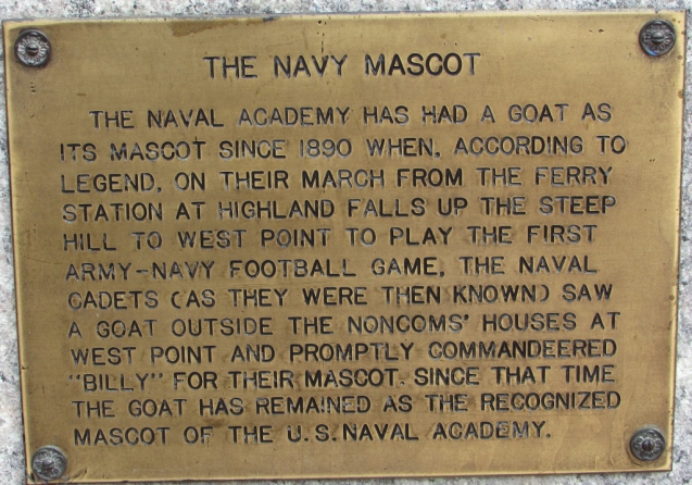
We’re going to leave you with the navy mascot, Bill the Goat:
Thanks so much for joining us on our journey! Please join us again soon. We really appreciate comments, likes, and follows. Until next time…
Travel safe, travel smart, and we will see you down the road (or at a national park!)
Mike and Kellye
As always, we strive to be as accurate with our information as possible. If we made a mistake, it was unintentional. (Hey, we’re only human!) We aren’t paid for our recommendations, and we only recommend our own tried and true vendors and venues. Our suggestions are for places that we’ve heard good things about but haven’t visited personally, and our opinions are our own.


 Today benches commemorating each of the Little Rock Nine can be found near the reflecting pool in front of the school. Statues of them also grace the grounds of the state capitol building. Every one of the nine students graduated from college. Some even went on to earn post graduate degrees, and some have written books about their experiences. Click

 Pecos National Historical Park is located near Pecos, New Mexico. The park protects the National Historic Landmark site which is composed of the ruins of an ancient pueblo and a mission church.

 Website link:


 Our visit to Pecos National Historical Park unfortunately did not take place on a day when they were offering tours of the Forked Lightning Ranch. Perhaps we will go back one day to take the tour because the ranch has a colorful past that includes a rodeo legend as well as some Hollywood royalty!
 Thank you for joining us on our road trip to Pecos National Historical Park! We hope we have inspired your wanderlust. Leave us a comment below and tell us about your own journeys. We would love to hear from you.


 found off the Strip as well as downtown, and there are many RV campgrounds in and around the city.