Featured

What is a Harvey House?

Harvey Houses, which were hotels and restaurants, served train travelers and locals for years along the Atcheson, Topeka and Santa Fe (ATSF) Railroad lines across the United States. Founder Fred Harvey came up with the idea while providing food service in railroad dining cars.

El Tovar Hotel in early 1900s.jpg
El Tovar Hotel, a Harvey House, opened in 1905.

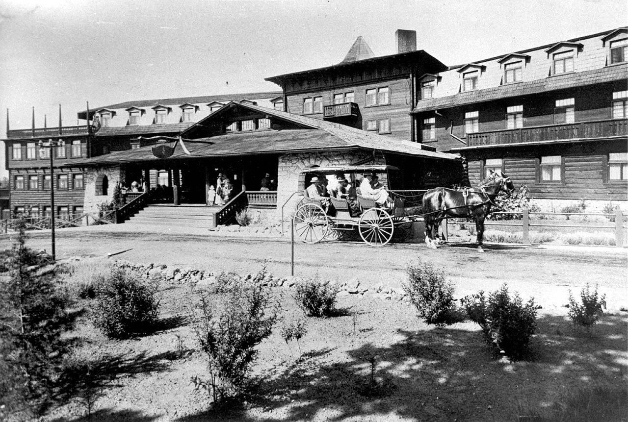
Our first Harvey House experience was the fabulous El Tovar Hotel at Grand Canyon National Park. A second Harvey House at the Grand Canyon is Bright Angel Lodge. Another one closer to home is located about 15 miles away from us in Slaton, Texas and is now a bed and breakfast. Though with that said, we are dedicating this post to the Belen Harvey House Museum in Belen, New Mexico. We would also like to recognize Heide, our lovely guide who taught us so much about Harvey House history.

Historic photo of the Belen Harvey House, built in 1910.

Where is it?

The Belen Harvey House Museum is located at 104 North 1st Street in Belen, New Mexico. Belen, which is the Spanish name for Bethlehem, is 34 miles south of Albuquerque on I-25. Access the museum’s website here.

Belen Harvey House Museum today, though this is a side view from the parking lot. The front of the building faces the train tracks located on the right.

Fred Harvey

Having immigrated from England in 1853 at the age of 17, Fred Harvey got a job as a dishwasher in a New York City restaurant. The restaurant’s owners taught him the complexities of the food service business, and he eventually became a busboy, waiter, and then a cook. Later, after working for a few years in a jewelry store, Fred and a partner opened their own restaurant, but the Civil War interrupted the venture. When the partner absconded with all of the profits, Fred was left holding the bag. Harvey eventually went to work for the Hanibal and St. Joseph Railroad in Missouri. After several promotions within the company, he was transferred to Leavenworth, Kansas where he remained for the rest of his life.

Fred Harvey, known as the first chain restauranteur and the man who civilized the Wild West.

In 1876, Fred made a deal with the superintendent of the ATSF Railroad after noticing there were few accommodations and no restaurants near most of their depots. The railroad would buy or build the buildings and lease them to the Fred Harvey Company. In turn, he would provide restaurants, workers, and hotel accommodations in or near the depots. A simple handshake sealed the deal, and the first Harvey House opened in Florence, Kansas in 1878 ushering in an era that would span almost 90 years. Fred Harvey died of intestinal cancer in 1901. After his death, his children and grandchildren ran the company into the 1960s. Harvey’s home in Leavenworth is now a museum.

Mary Elizabeth Jane Colter

Full length photo of Mary Colter sitting in an elaborate wicker chair that wraps around her.
Mary Elizabeth Jane Colter (National Park Service photo)

Fred Harvey hired Mary Colter, an architect and designer who designed many of the buildings at Grand Canyon National Park, to design his restaurants and hotels across the southwest. She remained the Fred Harvey Company’s chief architect and designer for 46 years, retiring in 1948 at the age of 79. Colter designed 21 hotels in addition to other buildings for the Fred Harvey Company, however, the Belen Harvey House was designed architect Myron Church.

Desert View Watchtower, Grand Canyon National Park

Grand Canyon National Park was the railroad’s most popular destination, so Colter was hired to design several buildings for the park. She designed the Desert View Watchtower, Hermit’s Rest, Phantom Ranch, and Lookout Studio, among others, all of which are still in use today. Mary Colter also designed the dinnerware that was used exclusively in the dining cars on the ATSF Super Chief, which ran from Chicago, Illinois to Pasadena, California.

Colter’s love of the southwest shines through in the designs and colors of this dinnerware on display at the Belen Harvey House Museum.

Harvey Girls

Women aged 18 – 30 were hired to serve as waitresses in Harvey Houses and to bring hospitality, beauty, and refinement to those establishments. Upon being hired, all Harvey Girls were sent to a one-month training program at the Vaughn, New Mexico Harvey House which no longer exists. Paid $17.50 per month plus tips, they worked 12-hour shifts six days a week. Uniforms plus room and board were perks of their employment. Free train travel along with Harvey House accommodations and meals during their one week per year vacations was another perk.

Harvey Girls with Mr. and Mrs. Porter who were the Belen Harvey House managers.

Recognizable by their black dresses and white aprons, these hard-working ladies lived in a dormitory in or near the hotel and even had a dorm mother. House rules were fairly strict. Men were never allowed to visit the girls’ living quarters, and the girls were strongly advised against fraternizing with the male railroad workers.

Example of a dorm room in the Belen Harvey House.

Nor could Harvey Girls converse with or flirt with the patrons. Their employment contracts purportedly contained an agreement stating that they would remain unmarried for at least one year after being hired. However, according to museum information, between 1883 and 1905 there were 8,260 marriages of Harvey Girls to railroad men, ranchers, cowboys, and fellow employees. Throughout the Harvey House era approximately 100,000 women worked as Harvey Girls.

Nothing But the Best But No Bathrooms

Insisting on nothing but the finest, Fred Harvey imported his table linens, dinnerware, and silverware from Europe. Although, interestingly, most of the Harvey Houses didn’t have public bathrooms. This was to prevent a passenger from missing or delaying a train.

Home | Belén Harvey House Museum
Belen Harvey House lunch counter and shiny coffee pots.

Travelers had limited time in which to have a meal before reboarding the train – usually about 25 minutes – because it took about a half hour to refuel the trains. Harvey House lunch counters were casual and were great for a quick sandwich, piece of pie, or cup of coffee.

Belen Harvey House Dining Room

Dining rooms, on the other hand, were formal. Because time was so limited, an ingenious system was developed to ensure that travelers had time to enjoy their meals. The 1955 menu below is from the La Fonda in Santa Fe. We have eaten there, and though it’s no longer a Harvey House they were still serving fabulous food at the time of our visit. We’re including the menu to show the delicious-sounding meals of the time.

Just look at those prices! Hot pineapple fritter with brandy sauce anyone? We had to laugh at the Postum and Sanka. Do they even make those anymore?

The Harvey House Legacy Lives On

At their peak, there were 84 Harvey Houses. The Grand Canyon’s El Tovar Hotel and Bright Angel Lodge are former Harvey Houses that are still in operation. La Posada opened in 1930 in Winslow, Arizona as Mary Colter’s self-proclaimed masterpiece. It is the only Harvey railroad hotel left in operation on Historic Route 66. In 2014, La Posada’s owner, Allen Allfeldt, bought the Castaneda Hotel in Las Vegas, New Mexico, which was Harvey’s first trackside hotel. After some rehabilitation, the Castaneda Hotel has reopened for overnight stays and dining.

Former Harvey House, Castaneda Hotel, in Las Vegas, New Mexico.
Castaneda Hotel’s beautiful dining room.
The Castaneda Hotel was built in 1898 and sits adjacent to the Las Vegas railroad depot which still serves Amtrak.

Visiting the Belen Harvey House Museum

  • Hours: 12:00 pm – 5:00 pm, Wednesday through Saturday.
  • Admission is free but donations are greatly appreciated.
  • Last admission to the museum is at 4:00 pm.
  • Grab a bite to eat in the new Whistle Stop Cafe.
  • Buy a souvenir in the gift shop.
  • Watch the trains rumble by on the adjacent tracks.
  • Tell Heide we said hello!
A glimpse of the front of the Belen Harvey House Museum.

Thanks so much for joining us on our visit to the Belen Harvey House Museum. If you enjoy history and museums, you may enjoy these other wonderful destinations:

Happy, safe travels, y’all!

Mike and Kellye

As always, we strive to be as accurate with our information as possible. If we made a mistake, it was unintentional. (Hey, we’re only human!) Our opinions are our own.

©2023                        

Featured

Zion National Park

We covered Zion National Park several years ago. This is a new post with enhanced content and updated information.

Zion National Park is approximately:

308 miles from Salt Lake City, Utah427 miles from Los Angeles, California377 miles from Phoenix, Arizona — 159 miles from Las Vegas, Nevada

The closest city with a major airport is obvious. So, pack your bag, stash some cash in your pocket, and get ready for a ride because our first stop is Las Vegas!

Iconic Welcome to Fabulous Las Vegas Nevada sign – Photo by Pixabay

Las Vegas

For first time visitors to Las Vegas, we recommend checking out the hotels/casinos on the Strip (officially Las Vegas Avenue). Each hotel has something different to see and do, and each one is worthy of a visit. Less expensive accommodations can be found off the Strip as well as downtown, and there are many RV campgrounds in and around the city.

Restaurant recommendations are difficult because we’ve never had a bad meal in Las Vegas. However, we think Emeril’s New Orleans Fish House at the MGM Grand and the buffet at the Wynn Las Vegas are definitely worth mentioning. As far as attractions go, there are too many to list here, but here’s a great link for things to do in Las Vegas.

Now, on to Zion National Park…

Leaving Las Vegas

Getting There

Take I-15 North toward Mesquite, Nevada and the Arizona state line.

Bonus stop: Valley of Fire State Park. Exit I-15 at Crystal, Nevada then take the Valley of Fire Highway to the park’s entrance. The park road is a Nevada Scenic Byway, and the park features hiking trails, spectacular red rock formations, and petroglyphs. RV and tent camping are available. Drive time between Las Vegas and Valley of Fire State Park: 47 minutes.

Continue on I-15 to St. George, Utah. Drive time between Las Vegas, Nevada and St. George, Utah: 2 hours.

Interstate 15 traverses the scenic Virgin River Gorge through northwestern Arizona into southwestern Utah.

Numerous hotel, dining, and camping options are available in St. George, Hurricane, and Springdale, Utah. Drive times to the park:

  • From St. George: 1 hour
  • From Hurricane: 32 minutes
  • From Springdale: 3 minutes. The park provides free shuttles around the town of Springdale and to the park for visitors who wish to use them.

Travel tip: the closer the hotel is to the park, the higher the rates.

From I-15, take Highway 9 east toward Springdale, Utah and Zion National Park.

The Watchman, Zion National Park

Destination: Zion National Park

Ahh…Zion! From finding peaceful solitude, to hiking, climbing, canyoneering, backpacking, or simply enjoying the beautiful scenery, Zion has an adventure for every visitor. It is also one of five national parks in Utah. So, depending on how much time you have, a visit to Zion could lead to visits to Bryce Canyon, Capitol Reef, Canyonlands, and Arches National Parks.

  • Website link: Zion National Park.
  • Accommodation in the park: Zion Lodge.
  • Restaurant and seasonal cafe at Zion Lodge.
  • Three campgrounds in the park.
  • Free shuttle. (Mandatory in Zion Canyon from spring through fall.)
  • When to go? Anytime. We like September.
  • Advance permits by lottery are required for hiking to Angels Landing. Check website for details.

IMG_1897 - Copy
No filters…the color is real!

Zion Canyon

 We highly recommend getting to the park early in the morning. Parking can be difficult during peak tourist seasons and the parking lots fill quickly. Overflow parking is available in Springdale, and the Springdale shuttle runs to and from the park. Hop-on hop-off shuttles inside the park run the length of Zion Canyon with nine different stops. We never waited longer than ten minutes for a shuttle in the park, however, we waited in line for almost an hour to get on one of the first shuttles of the day. Did we let that bother us? Absolutely not! The park was definitely worth the wait.

Travel tip: carry a backpack with everything you will need for a full day in the park, including lunch, snacks, and plenty of water. Now get ready to say “Wow” about a million times!

View from the canyon floor

Riverside Walk

From the visitor center, take the shuttle all the way up the canyon to the Temple of Sinawava shuttle stop. This is where the Riverside Walk trail begins. The paved trail, which follows the Virgin River, is easy, and it is the gateway to the Narrows. The Narrows is a ten to sixteen-mile hike in the river, and it is strenuous, but it is one of the most popular hikes at Zion. Check with the visitor center regarding river conditions before attempting the Narrows. After Riverside Walk, work your way back down the canyon by hiking other trails (check out Weeping Rock Trail) or by taking the shuttle to another stop.

IMG_1899
View of the river from Riverside Walk

Entering the Narrows

The Grotto Trail to Zion Lodge

This is an easy, one mile hike, and the scenery is so much more spectacular from a trail than from a vehicle. The shuttle stop at The Grotto is also the trailhead for Angels Landing, which is another one of the most popular trails at Zion. Angels Landing trail is long, strenuous, and not for everyone, but we hear the views are incredible. Advance permits are required for Angels Landing.

IMG_1939
Zion Lodge

Angels Landing

View from the Grotto Trail

Lower Emerald Pool Trail

From the Grotto trail, take the Lower Emerald Pool trail. This trail is just a little over a mile long, and it’s easy, though there are some inclines along the way.

IMG_1975
Lower Emerald Pool trail

Waterfall view, Lower Emerald Pool trail

Another view from Lower Emerald Pool trail

Kayenta Trail

Return to the Grotto shuttle stop via the Kayenta trail (moderate, 1.5 miles) for great views of the Virgin River and Zion Canyon.

Kayenta trail passes through a slot between the rocks

Tiny waterfall on Kayenta trail

Zion Canyon from Kayenta trail

Kolob Canyons

Drive time between the park’s Springdale/South Entrance to Kolob Canyons: 47 minutes via Hurricane, Utah and I-15.

This underrated section of the park, which is much less crowded than Zion Canyon, features:

  • Visitor Center with restrooms and a water filling station.
  • Breathtaking scenery in a designated wilderness.
  • 20 miles of hiking trails for all levels of hikers.
  • Kolob Fingers Road Scenic Byway – scenic drive. The road is five miles long with viewpoints and trailheads.
  • Kolob Terrace Road – another scenic road that begins in Virgin, Utah and runs for 21 miles in and out of the park. There are no services along this road.

Beautiful scenery awaits at Kolob Canyons

Adventurous hikers may want to venture into Kolob Canyons’ backcountry to view Kolob Arch. The arch, which pans 287 feet, is one of the longest natural arches in the world. The 14-mile roundtrip hike is rated strenuous. Check with the visitor center for recommendations on other hikes in Kolob Canyons.

Stunning Kolob Canyons view

Obviously, we have barely scratched Zion’s surface. There are many additional hikes, short trails, a museum, ranger led programs, and much more available in the park. Zion is a place where you can find your own level of adventure. We hope you have a fantastic trip! Leave us a comment below and let us know what made you fall in love with Zion. We would love to hear from you. Until the next trip…

Travel safe, travel smart, and we will see you down the road.

Mike and Kellye  

IMG_2120

As always, we strive to be as accurate with our information as possible. If we made a mistake, it was unintentional. (Hey, we’re only human!) We aren’t paid for our recommendations, and we only recommend our own tried and true vendors and venues. Our suggestions are for places that we’ve heard good things about but haven’t visited personally, and our opinions are our own.

©2022

Fort Union National Monument

Where is Fort Union National Monument Located?

Fort Union is located approximately 30 miles north of Las Vegas, New Mexico.

IMG_3168

  • Website link: Fort Union
  • Cost: free
  • Hours vary seasonally
  • Short film in the visitor center about the history of the fort
  • Self-guided or ranger-led tours of the grounds
  • Night sky programs
  • When to go? Anytime

Fort Union National Monument is 150 miles from Albuquerque, New Mexico, and since Albuquerque has a major airport, we will start our adventure from there.

IMG_3155
Prairie near Fort Union. Imagine a wagon train ambling along the Santa Fe Trail here. Aside from the barbed wire fences, this scene probably hasn’t changed much in the last 150 years.

Getting There

From Albuquerque take I-25 north toward Santa Fe. At Santa Fe continue on I-25/US 84 east toward Glorietta and Pecos, New Mexico.

Bonus stop: Pecos National Historical Park. We love this park so much that we have recommended it on our site before. Plan to spend a couple of hours taking the self-guided tour to see the remains of a pueblo that was built around 800 AD. The visitor center museum is also very interesting and definitely worth a visit. Here’s a link to the park’s website: Pecos National Historical Park.

Pecos Mission Church – built in 1717. Pecos National Historical Park, New Mexico

Continue northeast on I-25/US 84 toward Las Vegas, New Mexico, then continue north to the town of Watrous. Follow the signs from Watrous to Fort Union. Drive time between Albuquerque and Fort Union: 2.25 hours.

Hotels, restaurants, and RV/tent camping are available 30 minutes away in Las Vegas, New Mexico

Destination: Fort Union National Monument

Fort Union’s Officer’s Row

Establishment of the Fort

The “first” Fort Union was established in 1851 to be a supply depot and living quarters for soldiers serving to protect travelers and traders on the Santa Fe Trail. With the beginning of the Civil War in 1861, better living conditions were needed, and the fort’s original wooden buildings were refurbished or rebuilt with adobe and brick. Larger supply warehouses were added at that time, and Fort Union began providing supplies to all the forts in the region. This version, the remains of which we see today, is referred to as the “third” Fort Union.

IMG_3175
Mechanic’s Corral. This is where they stored and worked on the vehicles of the day and took care of the horses that pulled them.

IMG_3181
Outside view of the Mechanic’s Corral

Fort Union’s hospital was once the largest and finest medical facility between Kansas and California, serving soldiers and civilians alike. After the Civil War, the post continued to operate with soldiers in place to protect the Santa Fe Trail. The hospital continued to operate during this time too. However, with the advent of the railroad, the Santa Fe Trail became less traveled, and the fort was abandoned in 1891. Some wheel ruts on the trail can still be seen at Fort Union.

Fort Union’s Post Commander’s Quarters

IMG_3174

Visiting the Park

The visitor center is the first stop, along with the new museum that opened in August 2022. The trailway through the fort is approximately a mile long, the walking paths are level, and benches can be found along the way. We recommend bringing plenty of water. There is little to no shade, so if you’re visiting during the hot summer months plan to visit early in the day. Pack a lunch to enjoy at one of the picnic tables outside of the visitor center.

During certain times of the year visitors may find living historians reenacting life at the fort. Check the website’s events calendar for dates. While there, look for the pronghorns and other wildlife that live in and around the park.

For those wanting a little more history, visit the town of Watrous, New Mexico which is just 12 minutes from Fort Union. Watrous (La Junta) is a national historic landmark district located on the Santa Fe Trail. Here is a link to the national park service’s webpage: Watrous (La Junta) National Historic Landmark.

Information about the Santa Fe Trail can be found here: Santa Fe National Historic Trail.

Old aerial photo of Fort Union taken from a wayside sign in the park. Shown prominently in this photo is the “second” Fort Union designed in a traditional star shape of dirt and ditches as an effort to keep the Confederates at bay during the Civil War.

Thank you for joining us on our Fort Union National Monument road trip! Have you been to Fort Union or other historic forts? If so, we would love to hear about your visit. Comments can be left below.

Would you like to visit more national monuments? Click to view these interesting sites:

Scotts Bluff National Monument
Colorado National Monument
Fort McHenry National Monument and Shrine


Travel safe, travel smart, and we will see you down the road.

Mike and Kellye

IMG_2120

As always, we strive to be as accurate with our information as possible. If we made a mistake, it was unintentional. (Hey, we’re only human!) We aren’t paid for our recommendations, and we only recommend our own tried and true vendors and venues. Our suggestions are for places that we’ve heard good things about but haven’t visited personally, and our opinions are our own.

©2018


Death Valley National Park

IMG_2653

  • Website: Death Valley National Park
  • Hotels/resorts and campgrounds in the park
  • Restaurants and concessions in the park
  • Scenic drives
  • Historic sites
  • Hiking
  • Backpacking
  • Backcountry camping
  • When to go? Winter, early spring, late fall are the best times to visit. Visitors should be extremely cautious in the summer months when temperatures rise dramatically.

IMG_2580
Devil’s Golf Course – these “rocks” are actually salt crystals. The Panamint Mountains made a nice backdrop for this shot.

Getting There

Our trip is going to start in Las Vegas, Nevada, which has a major airport and is only 123 miles from Death Valley. Ice down a cooler full of water, grab your favorite road snacks, and let’s go to Death Valley!

From Las Vegas, take I-15 south to Highway 160 west to Pahrump, Nevada.

Travel tip: make a restroom stop and top off your gas tank in Pahrump.

From Pahrump, continue northwest on Highway 160 to Bell Vista Avenue. Take Bell Vista (which changes to Bell Vista Road) west across the California state line to Death Valley Junction and Highway 190. Continue into the park on Highway 190. Drive time between Las Vegas and Death Valley: 2 hours.

Travel tip: Look for wild burros and horses along Highway 190.

Destination: Death Valley National Park

IMG_2601Arguably, Death Valley holds the record for the hottest temperature ever recorded on earth – 134º F in July of 1913. Badwater Basin is the lowest point in North America, sitting at 282 feet below sea level. With an average of 1.5 inches of rain per year, Death Valley also holds the honor of being the driest place in North America. We are used to hot, dry weather where we live, but the 111º F (before noon) temperature when we visited Death Valley felt like a different type of oppressive heat that seemed heavier to us for some reason. With that said, we caution you to be conscious of the weather and prepare for harsh conditions when visiting this park, especially in the late spring, summer, and early fall. Also, make sure your car is in tip-top condition before starting a road trip through Death Valley.

IMG_2602
This is a spring in the salt flats at Badwater Basin, but the water is too salty to drink.

Death Valley is hot, dry, and its spring water is too salty for humans or animals to drink. So why would anyone want to go there? Well, see below…

IMG_2610
Breathtaking Beauty

IMG_2611
Vibrant Colors at Artist’s Palette

IMG_2626
Magnificent Mountain Vistas

When thinking of a desert, one usually thinks of sand dunes and scrubby cactus. At least that is what we envision when we imagine desert scenery. Death Valley is different from other deserts because of its diversity. The park features 11,000 foot mountains, wildflower super blooms after rare rains, as well as sand dunes. Badlands, salt flats, and dry lake beds where rocks race across the parched ground on their own, can also be seen here. With so much to offer, it’s easy to see the many facets of this unique landscape. And speaking of lake beds, all of Death Valley was once a lake. A trip here is definitely worth the time, and it’s not just about the scenery. This park also features oases, historic ghost towns, abandoned mines, and even a castle!

IMG_2629
Badlands of Zabriskie Point

IMG_2606
Salt Flats of Badwater Basin

IMG_2632
Multi-faceted Beauty

Did you know that borax was once mined in Death Valley? The mine was called Harmony Borax Works, and they hauled the borax 165 miles to Mojave, California, using huge wagons pulled by teams of twenty mules. One of the wagons can still be seen at the Furnace Creek Visitor Center. The trip from Death Valley to Mojave took ten days and had to have been grueling. Today at Death Valley, there is a park road through scenic Twenty Mule Team Canyon. While the wagons probably didn’t travel this exact area, it is a wonder how they managed to get their animals and wagons through the rugged terrain of what is now Death Valley National Park.

IMG_2639
In Twenty Mule Team Canyon

IMG_2636
View of the terrain and park road through Twenty Mule Team Canyon

Thank you for joining us on our trip to Death Valley National Park! We hope that we have given you some insight and inspiration for planning your own trip to see this wondrous place. That is our goal in sharing our information, after all. We will leave you with one last look at beautiful, otherworldly Zabriskie Point.

IMG_2631

Until the next trip…

Travel safe, travel smart, and we will see you down the road.

Mike and Kellye

IMG_2120

As always, we strive to be as accurate with our information as possible. If we made a mistake, it was unintentional. (Hey, we’re only human!) We aren’t paid for our recommendations, and we only recommend our own tried and true vendors and venues. Our suggestions are for places that we’ve heard good things about but haven’t visited personally, and our opinions are our own.

©2018